SkyWatch | LTA / ISR
AEROSTAT & HIGH-ALTITUDE BALLOON OPERATIONS: 180-DAY ANALYSIS

SKYGLASS WEEKLY FLIGHT OPS REVIEW
2025.04.28
Greetings, Intrepid SkyRider,
Welcome to the 11th edition of SkyWatch, the weekly flight operations review from AVIAR LABS. This week, we’re covering a less common but increasingly important aerial platform: LTA (Lighter Than Air) systems dedicated to ISR (Intelligence, Surveillance, Reconnaissance) missions.
We’ll take a close look at two key types of LTA|ISR platforms: the constellation of DHS aerostats (tethered LTA systems) and the high-altitude balloons operated by Raven Aerostar. Each brings unique capabilities and history to the ISR domain — details I found especially compelling.
Given the growing presence and critical influence these platforms have had in monitoring the U.S. southern border, this SkyWatch edition feels particularly timely.
Let’s get into it!
SkyWatch Target : [ LTA | ISR ]
Aerostat & High-Altitude Balloon Ops: 180-Day Analysis
Bottom Line / Up front : Over the past 180 days, lighter-than-air platforms — both tethered aerostats and free-floating high-altitude balloons (HBALs) — have played a critical and evolving role in aerial surveillance across CONUS and beyond. DHS aerostats provided persistent fixed-location radar coverage along U.S. borders and coastal approaches, while HBAL platforms operated in the stratosphere, moving slowly across regions for strategic overwatch missions.
This SkyWatch briefing provides a full operational overview of both platform types, technical insights, historical context, and a look at what their increasing use means for the future of aerial ISR.
DHS Tethered Aerostats
Assets: 8 sites (7 active)
Altitude Range: ~5,000–15,000 ft AGL
Movement Pattern: Stationary (tethered)
Regions: U.S. southern border, Florida, Puerto Rico
High-Altitude Balloons (HBALs)
Assets: ~10 tracked
Altitude Range: ~60,000–70,000 ft MSL
Movement Pattern: Long-endurance drift
Regions: CONUS, Mexico, Caribbean, Atlantic
Movement and Operations Overview
Highlights:
DHS aerostats remained on-station continuously, showing near-constant airborne presence at key surveillance sites.
HBALs demonstrated remarkable endurance, with some balloons operating over 200 consecutive days and traversing tens of thousands of nautical miles..
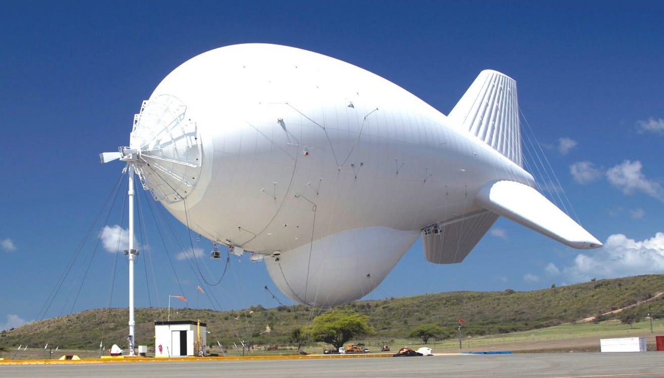
What is an Aerostat?
An aerostat is a balloon or airship that remains aloft primarily through buoyancy rather than thrust. Most operational aerostats today are tethered platforms, connected by a cable to a ground station, designed to hold surveillance or communications payloads at altitude for extended periods.
Key characteristics:
Lift is provided by lighter-than-air gas (helium).
Station-keeping is achieved through a mooring tether.
Power and data links can be run through the tether, allowing for sustained payload operation.
Aerostats are valued for:
Persistent surveillance: Loiter times measured in days to weeks.
Wide-area coverage: Elevated sensors dramatically expand detection horizons.
Cost-effectiveness: Operating at a fraction of the cost of aircraft or satellites.
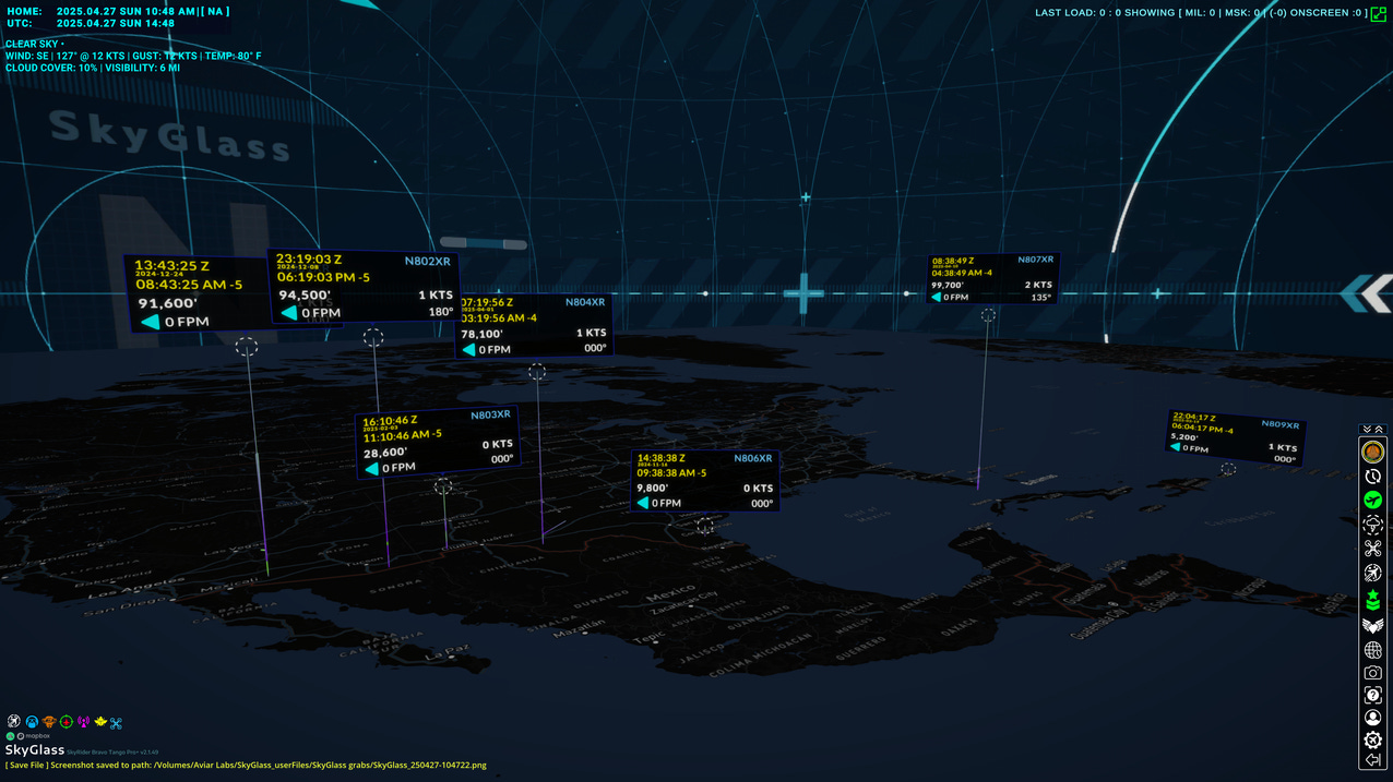
The image above shows the currently detected aerostat locations from the last 108 days. Although the operational ceiling is typically 15k feet, these aerostats often are reporting much higher from their onboard transponder.
DHS Aerostats: Border Guardians
The U.S. Department of Homeland Security (DHS) employs tethered aerostats as part of the Tethered Aerostat Radar System (TARS). Managed by Customs and Border Protection (CBP), the TARS network acts as a quiet, ever-watchful layer of border security.
Current Deployment
Eight known operational sites (with seven currently active) are located strategically along the southern U.S. border, in the Florida Keys, and Puerto Rico. Each site supports a helium-filled aerostat tethered to a ground station, elevating advanced radar systems to heights between 5,000 and 15,000 feet..
Mission Profile
TARS aerostats provide:
Low-flying aircraft detection: Identifying aircraft that might evade traditional radar by flying nap-of-the-earth profiles.
Surface vessel tracking: Supporting maritime domain awareness in coastal sectors.
Communications relays: Some aerostats double as airborne communications hubs, extending radio networks over remote terrain.
At 10,000 feet, an aerostat-mounted radar can detect targets over 200 miles away, covering vast swaths of terrain — a force multiplier for limited ground assets.
Platform Details
Each aerostat system includes:
Envelope volume: ~275,000–420,000 cubic feet.
Payloads: Long-range surveillance radars, EO/IR sensors, communications packages.
Tethers: Strong enough to resist >20,000 pounds of tension; fiber optics and power lines integrated.
Winches: Allow controlled launch and retrieval during storms or maintenance.
Operationally, aerostats stay aloft continuously, only descending for high winds or routine servicing. Over the last 180 days, SkyGlass tracking showed excellent uptime across most TARS sites, with notable constant coverage over Arizona, New Mexico, Texas, the Gulf region, and Caribbean waters.

HBAL728 and HBAL717 were observed loitering over the Gulf of Mexico, overlapping 300+ mile radius coverage areas, hinting at coordinated maritime monitoring operations.
High-Altitude Balloons (HBAL): Stratospheric Eyes
While aerostats dominate the lower atmosphere, high-altitude balloons (HBALs) operate in the stratosphere, well above commercial air traffic. Their endurance, low observability, and flexibility make them a compelling tool for modern ISR missions.

HBAL Origins: Project Loon to Aerostar
HBAL technology began with Google’s Project Loon, which aimed to deliver internet via stratospheric balloon constellations. After Google’s exit from the project, the technology transitioned to Aerostar’s Thunderhead program — retooled for defense, research, and tactical operations.
Thunderhead platforms today offer:
Altitudes: ~60,000–70,000 feet.
Endurance: 100+ days typical; 200+ days achieved.
Navigation: Passive altitude control exploiting stratified wind layers.
Payloads: EO/IR sensors, communications relays, signals intelligence (SIGINT) packages.
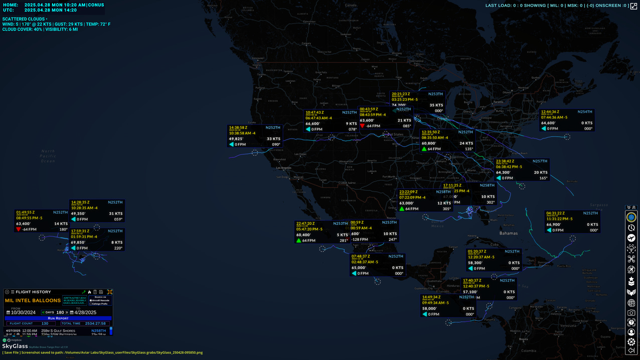
Above are the 180 day flight traces and a few typical telemetry datapoints showing altitude and time of reporting.
HBAL Operations: 180-Day Tracking
SkyGlass data shows a steady tempo of HBAL launches and global movement patterns:
Launch sites: U.S. interior (likely New Mexico, South Dakota).
Flight paths: Drift across CONUS, Gulf of Mexico, Caribbean, sometimes toward Europe.
Altitude behavior: Gradual day/night altitude modulation, solar optimization, and course corrections via wind layer selection.
Historical Context: Balloons in Conflict
Early Military Ballooning
1794: French Army launches observation balloons during the Battle of Fleurus.
1861–65: Union Army employs tethered balloons during the U.S. Civil War for battlefield reconnaissance.
WWI and WWII
WWI: Observation balloons become critical assets for artillery spotting.
WWII: Britain deploys barrage balloons over London to deter Luftwaffe attacks; Japan launches thousands of Fu-Go fire balloons aimed at North America.
Cold War
1950s: U.S. Project GENETRIX launches reconnaissance balloons over Soviet territory, predating satellite imagery capabilities.
Balloons consistently offered persistent, stealthy reconnaissance, often slipping under radar coverage and providing unique overhead perspectives.
Strategic Implications
Today’s aerostat and HBAL operations reflect both historical lessons and cutting-edge innovation:
Altitude
Aerostats: 5,000–15,000 ft
HBALs: 60,000–70,000 ft
Mobility
Aerostats: Stationary (tethered)
HBALs: Semi-steerable (riding stratospheric winds)
Endurance
Aerostats: Weeks (with maintenance cycles)
HBALs: 100–200+ days continuous
Detection Horizon
Aerostats: 200+ miles (radar coverage)
HBALs: 300+ miles (optical/SIGINT footprint)
Vulnerabilities
Aerostats: Weather sensitivity, tether risks
HBALs: Solar reliance, limited steering
Primary Mission Focus
Aerostats: Border surveillance, communications relay
HBALs: Global ISR, communications, scientific research
Advantages:
Persistent overhead presence without satellite cost or UAV logistics.
Large coverage footprints from small, quiet platforms.
Ability to silently monitor air, land, and maritime domains.
Challenges:
Weather remains a significant risk for both platforms.
Countermeasures, including high-altitude interceptors and directed energy systems, are evolving.
Outlook
The increasing operational tempo of DHS aerostats and Thunderhead HBALs indicates a growing reliance on lighter-than-air ISR layers.
Aerostats will likely see sensor upgrades (multi-sensor payloads, AI-enhanced detection) and expanded use in coastal and border operations.
HBALs will continue to fill the “near-space” layer between UAVs and satellites, supporting:
Persistent maritime domain awareness,
Battlefield communications,
Environmental sensing and research,
Early warning missions.
The evolving role of lighter-than-air ISR platforms — from tethered aerostats to stratospheric balloons — highlights a critical shift in aerial surveillance tactics. Persistent, cost-effective, and difficult to counter, these platforms are reshaping the intelligence landscape in ways we must continue to watch closely.
~•~
That concludes this week’s SkyWatch report. Before you go, a few notes…
At AVIAR LABS, we built SkyGlass to give you real-time, 3D insight into these operations and beyond. Whether you’re tracking tactical deployments, mapping surveillance footprints, or analyzing historical movements, SkyGlass Pro and Pro+ levels unlock the full depth of global flight operations, airspace analysis, and time travel replay features.
Engage in SkyGlass Pro / Pro+
If you found today’s SkyWatch valuable, you’ll find even greater depth inside SkyGlass Pro+. Up-level your Aviation OSINT game with SkyGlass Pro and Pro+.
Join the SkyGlass Community
Follow SkyGlass on X (Twitter) | YouTube | LinkedIn | Discord
Stay sharp and keep looking up.
Best regards,
Goa.